

A spreadsheet-driven tool which assist pilots in planning flights across the US in minutes.
A flight planner, automated with up-to-date weather, fuel calculations, and information on over 13,000 operable airports and runways in the US.
Official link to the planner
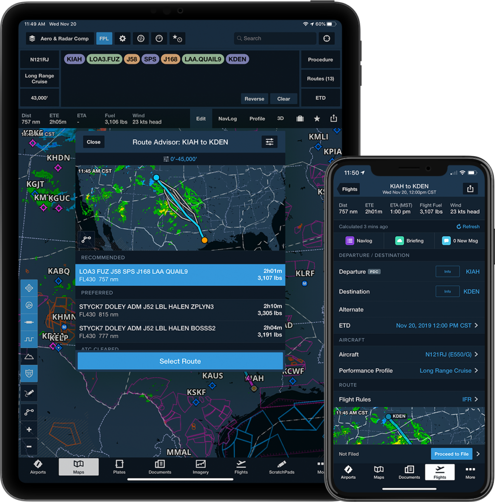
If you are a pilot, then the program ForeFlight might ring a bell for you. ForeFlight is a fantastic tool: that is, if you have a fully charged tablet, with service. Once you gain altitude or forget to charge the device, you’re in the dark. All remaining airport and communication information either remains in your sectional or GPS, if you know how to use them. Accessing information can be dangerous, even when not in a critical situation.
If you aren’t a pilot yet, you might not know this: flight plans are done with paper and pencil on a sectional chart, when considering flight under Visual flight rules. They tell you important information about your flight plan: things like elevation, communication frequencies, distances, headings, etc. These things take time to calculate… there is no wonder that pilots love using ForeFlight!
But now, I present you my flight planner. It’s something you fill out in a minute and print right before your flight. It gives you your headings for all of your points, distances, everything! But, for simplicity, I have split up the tool into three parts.
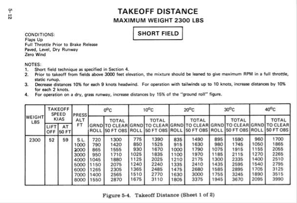
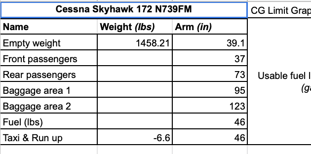
Each airplane is different. You have Cessna Skyhawks, Archers, Pipers, etc. with each having their own particular categories! This means that, with each different model airplane, are different specifications in the POH. Rather than attempting to remember what each moment arm is or what the empty weight is, I implemented a place where you can write this down one time and forget about it. The same thing applies to your tables: Cruise, takeoff, and landing tables can all be filled out to be identical to your POH.
So now, if you rent the same plane you rented out three months ago, you can use your old data. This is provided nobody changed the empty weight in significant manner. However, the tables are never updated once they are written down by the manufacturer, so there is little maintenance to the data sheet.
Input:
A requirement for flying, as pilot, means you have a weight and balance in the plane at all times. Rather than worrying if you are overweight with your passengers and doing a weight and balance by hand, you can input what goes where in your sheet. And as a result, you can complete your Weight and Balance in less than a minute, along with tons of supplementary info. From fuel consumption to takeoff distance, this is an all-in-one information center about your airplane. There even is an automated CG grapher for your convenience to show you if you are within your weight limits.
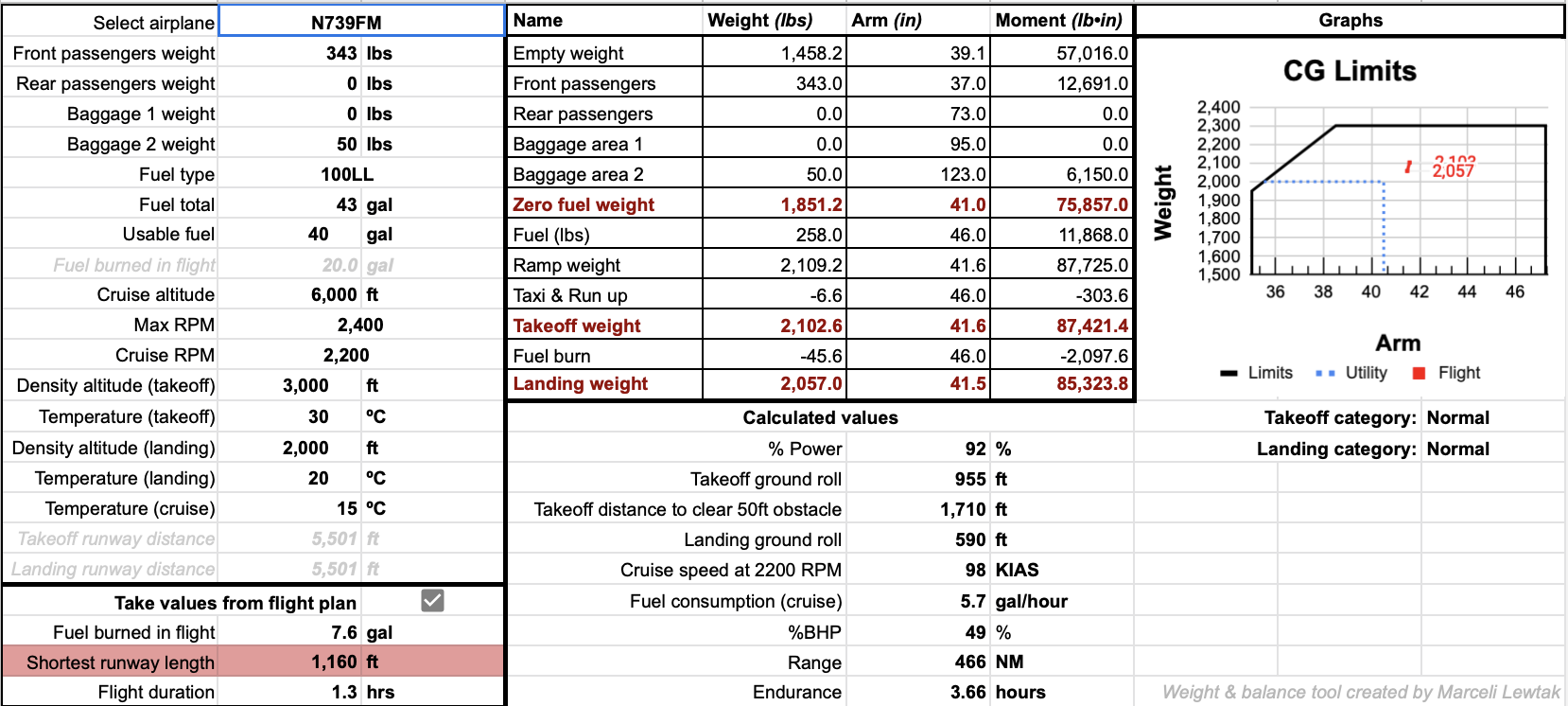
The important takeaway from the Weight and Balance is limitations. A pilot has a responsibility over their plane and all accompanying passengers & cargo. A pilot cannot be sure they are within their limits without completing a weight and balance. So, this tool lets pilots spend less time doing grunt work and more time understanding their plane’s stability. Playing around with the tool is really helpful to realizing how the stability of the plane changes with weight distribution!
Input:
Output:
By far the most complex part of this project, this is the Flight planner itself. The name is self explanatory: here, you plan your waypoints to your destination. The most popular waypoints: airports. There are 13,000 airports riddled across the US, each with their own runway information, communication frequencies, and so on. It’s impossible to memorize all of this information for longer flights, so pilots tend to use programs like ForeFlight to assist them in their cross-country flights.
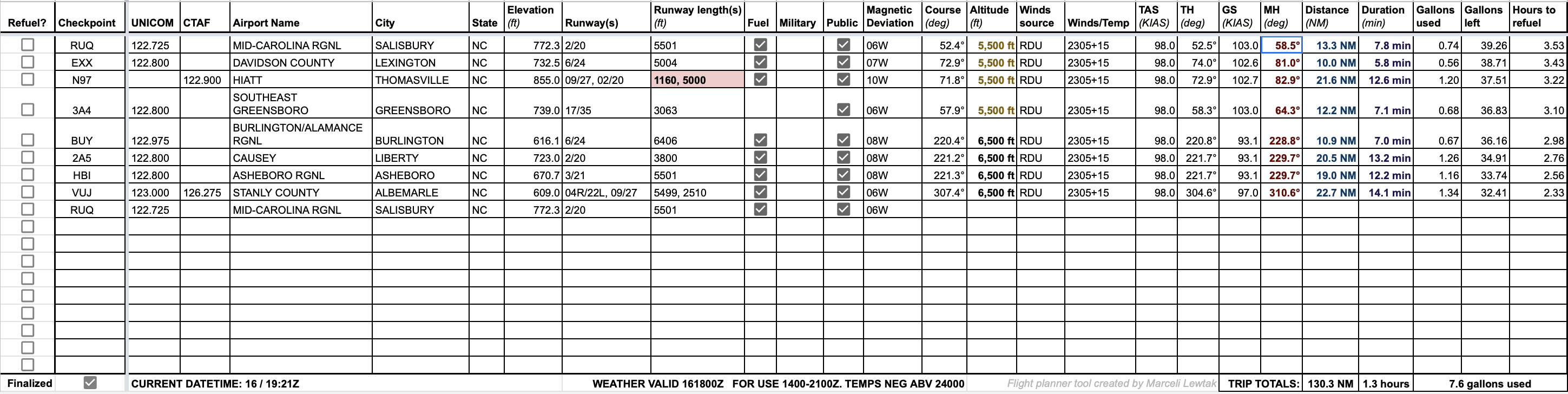
This Flight planner does the exact same thing, except it’s printable. You can take it with you, and it gives you all relevant information you need about where you’re flying. It’ll tell you if you need to refuel along the way, or if the runway at the airport is a bit too short for your plane.
Input:
Output:
Airport information:
Trip information:
As with each item in my portfolio, there was an aspect of coding involved. In this project, it was mathematically intensive Excel code. Here are a few highlights from my coding and research.
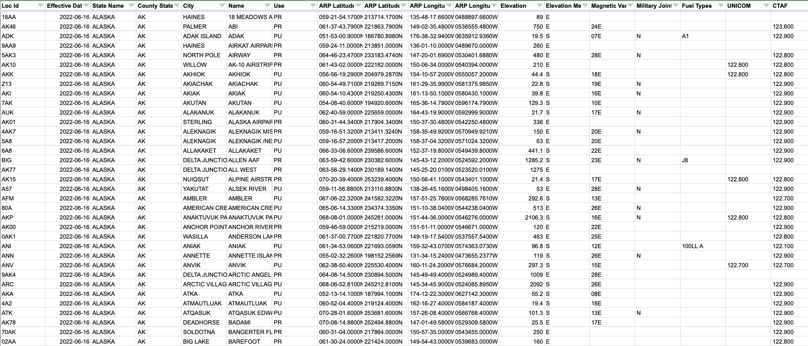
To even start coding through the project, I needed to get my hands on airport data. Fortunately, the FAA publishes a list of operational airports in the US every month. This is a sheet containing more than 13,000 airports, along with several integral pieces of data in varying columns. One of the most integral to the planner were its longitude/latitude coordinates, which eliminated the need for using a handheld flight protractor. Below is a screenshot example of the data I worked with.
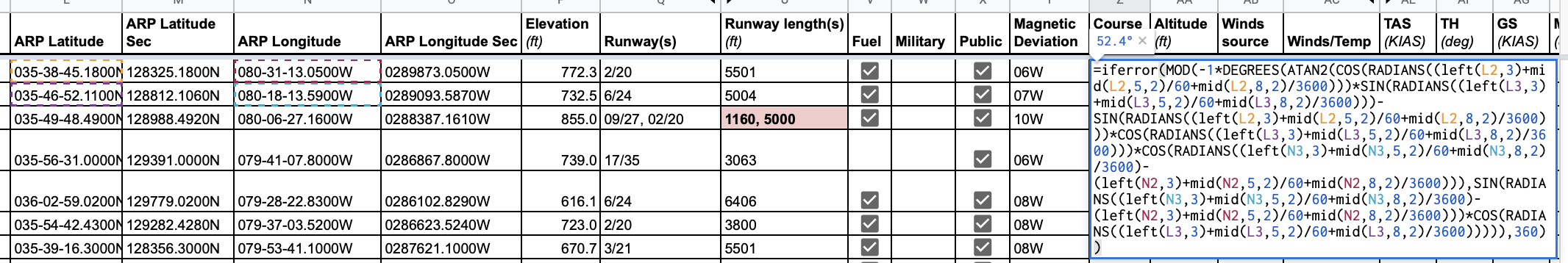
Fortunately, each airport had latitude and longitude information provided. This meant I could include information such as distances between airports and headings using trigonometric-heavy calculations. I included a sample of what these calculations looked like below. Figuring out how to do the calculation was the challenging part: I had never worked with longitude/latitude as units before. But, once I finalized the calculation, the rest was done for me.
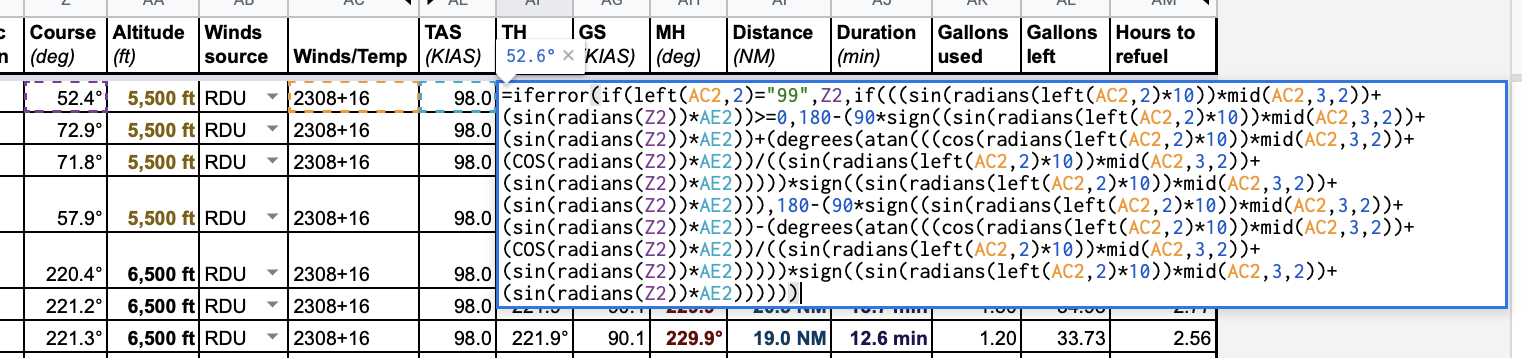
This was the most challenging part of the calculations. Excel has no built-in method of doing dot product calculations, so I had to manually do the derivation for this. Also, the Winds/temp source displays where the wind is coming from, I had to take its reciprocal. From there, it was simple addition due to the principal of linear superposition. An example of this calculation is also presented below.
Overall, this project took approximately two weeks to create, format, and finalize. Only from actual use in the cockpit was I able to improve on the calculator. In flight, since certain pieces of information are more important than others, so I bolded + colored the most important ones. I am incredibly proud of this project, even though it’s nothing super complex. The convenience and practicality of the project makes it incredibly useful in flight. Ever since I have finished, I have been using it avidly for my flight plans, and foresee myself using this in the future.